SB79 Adoption
June 17, 2026
Alex Frost
Principal Planner
Planning Department, City of San Diego
RE: SB79 Adoption
Whereas SB 79 specifically provides a process for local jurisdictions to tailor its requirements to address local conditions, the Normal Heights Community Planning Group has elected to provide recommendations for the adoption of SB79 within the bounds of the Normal Heights Community Planning Area:
- Adopt a “transit-oriented development alternative plan” (TOD) consistent with Government Code 65912.161(a) having:
- an exception for sites within a very high fire hazard severity zone,
- an exemption of areas outside of a one mile walk from TOD Stops from SB 79 application,
- an exemption of areas where no walking path under one mile connects a site to a TOD Stop,
- and modifications to Floor Area Ratio (FAR) between RS-1-1, RM-1-1 and RM-2-5, CUPD-CT-2-3, CUPD-CT-2-4 zones as laid out in Appendix A.
- Opt out of phased implementation as described in Government Code Section 65912.161(b)(1)(B)(iii).
The TOD details were reviewed by the board on June 2nd with considerations for land redevelopment, density, scale, architectural features, parcel sizes, practicality, zoning, and overlays for Complete Communities Housing Solutions and ADU Bonus Program, as well as the Mid-Cities Community Plan Update and the proposal submitted by the Kensington Talmadge Community Planning Group.
Opting out of a phased implementation was successfully argued by both board members concerned about impacts to the Community Plan Update in progress and a resident of the impacted area who expressed a desire to see redevelopment.
Respectfully yours,
Paul Coogan
Chair, Normal Heights Community Planning Group
Cc: Apharna Padmakumar, Associate Planner; Morgen Ruby, Senior Planner; Selena Sanchez Bailon, Assistant Planner; Victoria LaBruzzo, Chair, Community Planners Committee; Niel Winner, Chair, Kensington Talmadge CPG; Marcellus Anderson, Chair, City Heights CPG; Lynn Edwards, Chair, Eastern Area CPG; Kanoa Cavaco, D-9 Outreach; Fatima Maciel, Mayor’s Office; Maya Rosas, Policy Advisor D-9
Appendix A – Modifications to FAR
We estimate that SB79 requires 12.5 million square feet of allowable FAR within the boundaries of tier 2 and tier 3 TOD areas defined by SB79. Parcels along El Cajon Blvd fall within the Complete Communities Housing Solutions (CCHS) overlay and qualify for FAR greater than the maximum SB79 FAR.
The table below models three scenarios:
- SB79: Maximum FAR square footage specified by SB79 without consideration of CCHS overlay.
- SB79 + CCHS: Maximum FAR square footage specified by SB79 for areas outside the CCHS overlay plus the average FAR allowed by CCHS (6.0 + 7.5 / 2) assuming affordable housing may not be included in all projects.
- Alternate TOD: Maximum FAR square footage specified by SB79 for areas outside the CCHS overlay plus the average FAR allowed by CCHS (#2) after applying 200% SB79 FAR in CCHS overlay areas and 50% SB79 FAR in areas outside the CCHS overlay area.
| Map Area | SB79 | SB79 + CCHS | Alternate TOD |
| SB79 Tier 2 & CCHS | 1,400,928 | 3,782,504 | 3,362,226 |
| SB79 Tier 2 | 2,279,063 | 2,279,063 | 1,139,531 |
| SB79 Tier 3 & CCHS | 2,747,763 | 7,418,959 | 6,594,630 |
| SB79 Tier 3 | 6,108,005 | 6,108,005 | 3,054,003 |
| Total | 12,535,758 | 19,588,531 | 14,150,390 |
The Alternate TOD supplies an additional 1.5 million square feet above the SB79 minimum while maintaining areas zoned RS-1-1, RM-1-1 as they are currently. This approach has several benefits to the city, developers, and the community.
Appendix B – Benefits
Benefit to the City of San Diego
The combination of an alternate TOD and opting out of the phased in approach will allow for:
- Consistent zoning/FAR on both sides of SR-15 when considering the Alternate TOD proposed by the Kensington Talmadge CPG.
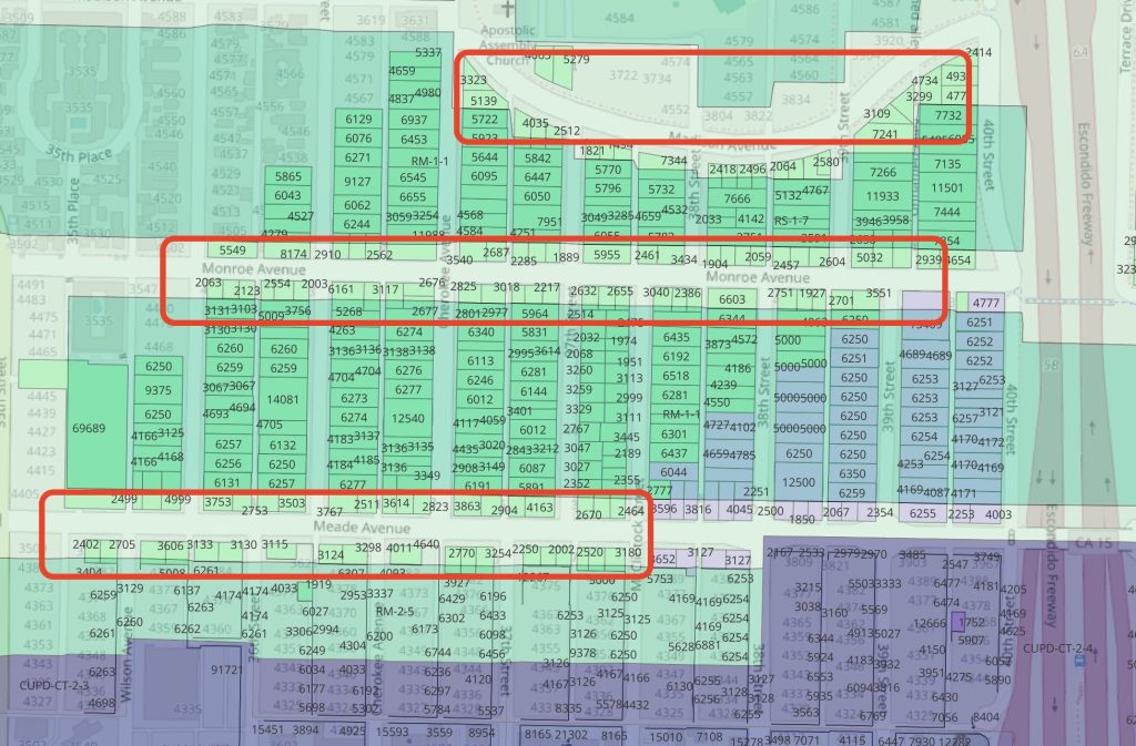
- Reduced confusion about FAR in an area with inconsistent zoning. The east/west streets of Madison, Monroe, and Meade are zoned RS-1-1 superseding north/south streets zoned RM-1-1.
- The mix of zoning within the grid mentioned above needs to be reviewed as part of the Mid-Cities Community Plan Update.
Benefit to Developers
Developers will find:
- Consistent FAR specification on both sides of SR-15 if there is alignment with the Alternate TOD proposed by the Kensington Talmadge CPG.
- Parcel sizes located outside the CCHS overlay and within SB79 Tier 2 & 3 are typically very small (Min = 1470, Median = 4292) requiring acquisition of multiple contiguous parcels to build anything significant.
- Parcels within the CCHS overlay provide a much better opportunity for development of multiple dwelling units within a single structure while the ADU Bonus program allows for ministerial development on any parcel with unused FAR.
Benefit to the Community
The area outside the CCHS overlay is a mix of pre-war bungalows, post-war additional dwelling units, multifamily apartment complexes of 6 or 8 units. The area needs a comprehensive redevelopment program that is not a piecemeal approach. The fragmentation of this area has led to the devaluation of older homes in the bungalow style over the past decades as they become overshadowed by the sporadic installation of larger structures. Residents local to the area have expressed a desire for redevelopment and additional housing units as long as it is done ina planned and meaningful way.
Appendix C – Maps
El Cajon/SR-15 Transit Center Area Impacted by SB79
This map shows the overall area near the El Cajon/SR-15 transit center contained in SB79 tiers with a secondary overlay to indicate CCHS.
- Light Green = SB79 Tier 3 + No CCHS
- Dark Green = SB79 Tier 3 + CCHS
- Light Purple = SB79 Tier 2 + No CCHS
- Dark Purple = SB79 Tier 2 + CCHS
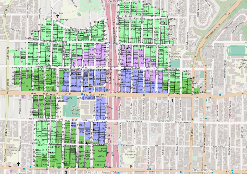
Normal Heights Area Impacted by SB79
This map shows the overall area near the El Cajon/SR-15 transit center contained in SB79 tiers with a secondary overlay to indicate CCHS for Normal Heights only.
- Light Green = SB79 Tier 3 + No CCHS
- Dark Green = SB79 Tier 3 + CCHS
- Light Purple = SB79 Tier 2 + No CCHS
- Dark Purple = SB79 Tier 2 + CCHS

Mixed Zoning within Normal Heights South East
This map depicts the intermixing of RS-1-1 and RM-1-1 zones due to efforts to maintain a single family home look along the east/west corridors. These parcels are often too small for even ADU additions.